Steamboat Springs, Mount Zirkel – 3rd Edition
Sky Terrain Trail Maps' Steamboat Springs Mount Zirkel is a 1:50,000 scale map that covers 16 USGS quads. The towns shown include Steamboat Springs, Clark, Columbine, Hahns Peak and Milner. A huge stretch of the Park Range and the Continental Divide is map
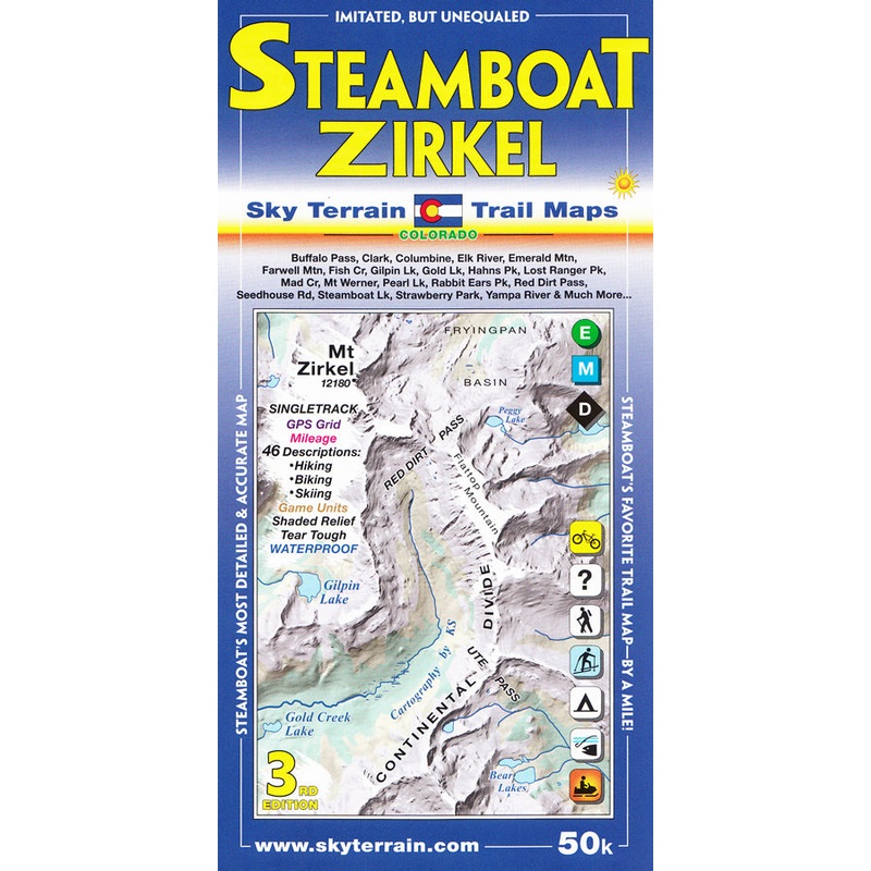
Sky Terrain Trail Maps’ Steamboat Springs Mount Zirkel is a 1:50,000 scale map that covers 16 USGS quads. The towns shown include Steamboat Springs, Clark, Columbine, Hahns Peak and Milner. A huge stretch of the Park Range and the Continental Divide is mapped, with the mighty Mount Zirkel at the highest point.
Other highpoints are Lost Ranger Peak, The Dome, Mount Ethel, Big Agnes Mountain, Rabbit Ears Peak and conical Hahns Peak. Buffalo Pass, Rabbit Ears Pass, Ute Pass, and Red Dirt Pass.The entire Elk River is revealed, as well as a long stretch of the Yampa River and smaller creeks like Soda Creek, Spring Creek, Fish Creek, Mad Creek, Walton Creek and more. Whitewater classes and put-ins & take-outs are shown as well as numerous alpine lakes such as Luna Lake, ThreeIslandLake,GilpinLake,GoldCreekLake & DinosaurLake.
Specs
- Two maps cover 8USGS quads each
- Each map offers ideal coverage of the towns and nearby famous passes and mountain ranges
- Shading tints and contours enhance elevation cues and organize complex terrain
- Trail rating symbols with trails rated difficult, moderate and easy
- Key roads also rated for road biking and mountain biking.\
- Singletrack symbols for mountain biking
- Game Management Units for hunting
- Trail mileage shown between junctions
- 46 trail descriptions including directions, trail lengths, elevation gains, noteworthy features and more
- Historic routes shown for reference
- Ideal contour levels (80 feet) set to improve visualization of terrain forms and maximize elevation information
- Additional key spot elements provided for reference
- Careful mapping and graphic stressing of natural hydrography to improve comprehension of the terrain forms
- Severalwaterfalls and cascades published here for the first time
- Full UTM grid for easy use with GPS receivers
- Printed on waterproof, tear-tough material for years of hands-on use


Reviews
There are no reviews yet.